During the data collection for Season A 2025, the SAS was carried out across all 30 districts of the country, gathering data from 1,200 segments and 382 large-scale farmers. The season’s data collection started on December 1st, 2024, and was concluded on February 15th, 2025.
Land used for agriculture
The total land area of the country is estimated to be 2.376 million hectares, with 1.399 million hectares (approximately 59% of the total land area) used for agricultural purposes.
The total land area of the country is estimated to be 2.376 million hectares, with 1.399 million hectares (approximately 59% of the total land area) used for agricultural purposes. In 2025 Season A, 1.019 million hectares were allocated to Seasonal crops, 0.492 million hectares were allocated to permanent crops, while0.096 million hectares were allocated to permanent pasture.
Use of seeds
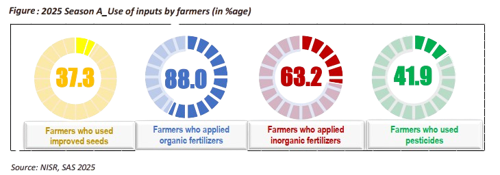
In Season A of 2025, 37.3% of farmers used improved seeds. Among farmer types, 35.9% of small-scale farmers (SSF) and 85.4% of large-scale farmers (LSF) adopted improved seeds. Organic fertilizer was applied by 88.0% of farmers, including 88.3% of SSF and 77.5% of LSF. Inorganic fertilizer was used by 63.2% of all farmers, with 62.4% of SSF and 91.9% of LSF applying it.
Use of pesticides
In season A of 2025, 41.9 % of farmers applied pesticides. According to farmer type, 40.6 % of small-scale farmers and 86.9 % of Large-Scale Farmers applied pesticides respectively (See Figure 3). Rocket, Dithane and Cypermethrin were the most used pesticides with 41.7 %, 18.6 % and 16.3 % respectively.
TABLE: List of Rwanda Land cover classes (SAS 2025)
| Land cover class name | Area (Ha) | Percentage share |
| Agricultural land on hills | 1,307,956 | 51.7 |
| Non-rice Agricultural Wetland | 56,905 | 2.2 |
| Mixed rangeland | 127,640 | 5.0 |
| Low density builtup area | 95,740 | 3.8 |
| Paddy rice wetland | 22,825 | 0.9 |
| Tea plantation | 23,732 | 0.9 |
| Non cropped wetlands | 36,846 | 1.5 |
| Forest | 381,391 | 15.1 |
| National parks | 190,247 | 7.5 |
| Water bodies | 155,030 | 6.1 |
| High density builtup area | 58,657 | 2.3 |
| Protected wetland | 45,883 | 1.8 |
| Bare land/rocks | 15,412 | 0.6 |
| Exclusive rangeland | 13,064 | 0.5 |
Irrigation practices
In season A of 2025, 13.4 % of farmers practiced irrigation. This included 12 % of small-scale farmers and 64.1 % of Large-Scale Farmers. Out of farmers who practiced irrigation 55.5 % practiced the modern irrigation. In regard to source of water, Lakes/stream and underground water were the most used sources of water for irrigation with 47.3 % and 30.3 % respectively.
Erosion control measures
In 2025 Season A 90.3 % of farmers practiced anti-erosion activities where 90.1 % of small-scale farmers and 97.4 % were Large-Scale Farmers protected their land against erosion.
Cover plants was the most used type of anti-erosion with 56.7 %. The farmland experienced less erosion where the predominant erosion types were those with a low degree of erosion (splash and wind erosion, which accounted for 53.3 % and 32.3 % respectively.
46.2 % of farmers practiced agroforestry, while 0.9 % of farmers used mechanical equipment in their agricultural activities.